Tuesday, 16 April 2013

South West Coast Path Section 9 Clovelly to Hartland Quay


Clovelly From Quay
It seems to have been a tradition that when I head to the South West the first day's weather is superb in order to reel me in, but then deteriorates just as I am getting into my stride. I could not say that today. I felt a bit lethargic when I arrived at Hartland and the rather cheerless looking weather didn't help. However, when I got on the bus the clouds looked like they might shift away quite quickly.

Clovelly Church
I got off the bus near to Clovelly Church, high above the famous village. There were plenty of signs of spring in the churchyard with daffodils growing in profusion. The church itself was typical of this part of the country, being rather plain and austere in design but with a wonderfully mottled look as it had been colonised by so many different species of lichen. I enjoyed looking at the stained glass and a very prominent memorial in the church yard before continuing on my way. I took the woodland path from the church down to the top of the village, where I met up with the Coast Path again. However, before setting off for the return journey to my car I thought it was right and proper that I should do the tourist thing and pop into Clovelly itself. I had been to Clovelly a couple of times before and no matter how touristy it is, the set up of the place is breathtaking.

Sea View
Clovelly is maintained as a traffic free village - not surprising when you see the steepness and narrowness of the main street down to the Bristol Channel. Being a pretty bleak day had its advantages when I arrived - the village was almost completely devoid of people and I was able to linger and explore without anyone being in my way. I went all the way down to the harbour wall, grabbed some refreshments at the hotel at the bottom and then watched amazed as fresh supplies were delivered by a man dragging a sledge behind him. No doubt this provides entertainment for the tourists but I reckon it is actually the only practical way of getting stuff down to where it needs to be.

Steep Climb
Although Clovelly is a village of undoubted antiquity I was suprised to note that many of the houses dated from the early part of the 20th Century and can only assume that these were replacements for earlier dwellings. It must have been fun getting the building materials down to the point of use!

New Inn
As I climbed back up the cobbled street, people started to arrive for their day trips. One hapless little girl of no more than about four years old decided it would be fun to run down the hill whereupon she tripped over a cobble and went flying. I expected floods of tears to ensue but looking at her bewildered face it soon became clear that she didn't actually hurt herself. When she realised that she had dropped her biscuit however her face crumpled and I was glad I wasn't the parent who had to pick up the pieces.

Angel Wings
At the top of the hill I headed right onto the Coast Path. It was a nice easy start through what looked like a deer park (although there were no deer to be seen). I soon came upon a small cabin in the woods that I supposed would be the limit for most strollers from Clovelly. I paused for awhile and enjoyed the view. For the next little while the walk carried on from where it had left off the previous day as I headed through the woods that cling to the steep cliffs of this lonely part of the Devon Coast. To my surprise I came upon another shelter a little further on, this one far more ornate. It was apparently named Angel Wings and was built by a butler at the Clovelly Estate nearly 200 years ago!

Mouth Mill
Any notion that this would be an easy walk were soon dispelled when the path suddenly started to lose height. The steep sided cliff on the side of me had also given way to a much rockier and sheer cliff line. The screech of gulls started to be heard above the sound of the trees swaying in the not inconsiderable wind. At the bottom of the slope the path did a little dog leg and headed down a forest track to a place known as Mouth Mill. On the way I passed what looked like a group of Scouts hunched over their cooking stoves trying to get together some lunch. It all seemed like rather hard work to me!

Blackchurch Rock
Mouth Mill was a rather desolate looking place, with the ancillary buildings looking as if they had been derelict for some time. The nearby cottage was still very much lived in, but I cannot imagine how lonely it must be living there. I crossed the stream by means of the pebbles that had dammed the mouth (like so many of the streams in these parts). Apparently one of the forthcoming projects to improve the path is to provide a better crossing here, but I found it ok.

Grazing With a View
On the other side was the first zig zag path of the day up through the woods to Brownsham Cliff. I plodded up there taking it steadily but watching only my feet in front of me, Imagine my surprise then when a couple coming down the hill suddenly wished me good morning! I almost jumped out of my skin! We exchanged pleasantries before continuing in our respective directions. At the top of the climb I came upon another oddity - what looked like a spool of something that looked like plastic tape. Whatever its function was the weather had obviously disrupted it and caused quite a mess!

East Titchberry Cliff
My gain in height did not last long, for only after one field I was heading downhill once again to Windbury Waterfall. On the way down to the bottom I passed a couple with a very frisky looking dog who clearly thought I was heading her way to play ball with her! I also momentarily got a glimpse of sunshine here, suggesting that perhaps I might see some nice weather after all?

Titchberry Cliffs
The climb back up the other side was quite rewarding in that I got to see a wonderful view of the arch back at Mouth Mill. At the time I could only guess at its existence but now I could see it in all its glory. Having regained the height I wasn't to lose it for some time. However, this was a mixed blessing for I had also left the woods behind me and my onward walk for some considerable time was through field after field. The wind got fresher and more fierce as time went on and I even saw a few flakes of snow. I can honestly sa that this was the coldest stretch of the Coast Path I have ever walked. To add insult to injury, I soon came upon a field that had recently been muck spread. To say it was rank would be a massive understatement. Any notion that it would be the only one was soon scotched though - I ended up having to endure three of them! My only respite was occasionally to change direction and get a blast of wind!

Hartland Mushroom
I got a couple of my first of two reminders of how the World Wars touched this remote part of Devon. The first was a plaque to commemorate the crashing of a Wellington Bomber into the cliffs here in 1942, killing all of those on board. Later I would see perhaps a more poignant memorial, this time to the Hospital Ship Glenart Castle, which was sunk by a U-Boat in February 1918 losing the entire crew and medical staff of 162 souls.

Hartland Point
I eventually reached the radar station just before Hartland Point, standing proud like a huge mushroom in the landscape. This rather odd looking structure is apparently used by air traffic control for civil aviation. The path headed all round the perimeter and then down to the car park for visitors to Hartland Point. I was thrilled to find a little shack open for selling cups of tea and immediately availed myself of one. To say it was welcome would be a massive understatement. It wasn't really the conditions to be sitting around for very long though and once I had drained my cup offI set once again.

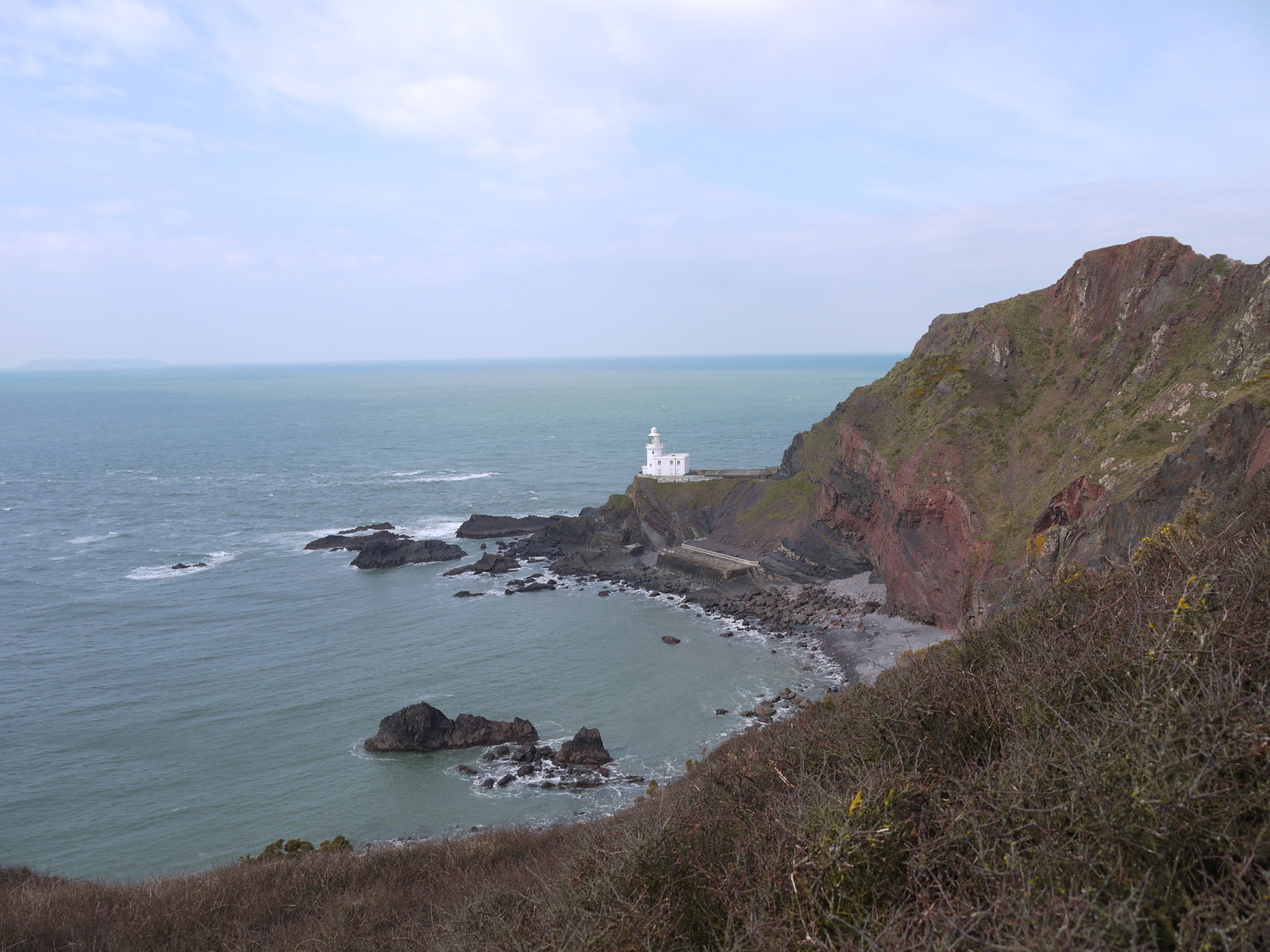
Damehole Point
Hartland Point Lighthouse is sadly not open to the public and looking at the access road I can see why. Most of it has succumped to landslips and erosion, making the old road almost completely unserviceable. However, upon climbing high up on to the headland I got some excellent views of the lighthouse. Offshore I was also at the nearest point yet to Lundy Island, the looming mass of which had followed me for the entire day's walking so far. Seeing it was bathed in sunshine led me to suspect that we would soon see some clearer skies too.

Dog Violets
As I turned away from Hartland Point towards Hartland Quay, some three miles distant, I saw the remains of the MS Johanna that had foundered on the rock below back in 1982 when carrying a cargo of wheat from the Netherlands to Cardiff. Fortunately in this case all the crew were rescued and the ship has been left to the mercy of the waves. I suspect that what is left won't last too many more years.

Blackpool Mill Cottage

Shortly after this the sun did comeout for the rest of the walk and I could enjoy the beginning of the Atlantic Coast in all its glory. The Bristol Channel coast was fun but immediately turning the corner at Hartland Point and the character changed completely. Stretching away before me was a much rockier coastline with gorse bushes replacing the trees and the land was a sea of yellow as we reach the zenith of the gorse season. After the cold and bleak section heading towards Hartland Point I now had three miles of testing climbs and descents and this presumably gets the walker into the mood for the next section into Bude, reputedly the hardest section of the entire Coast Path.

The Pleasure House
Luckily I was in no hurry and took my time over this section, enjoying the sunshine and my surroundings in a way that had been quite difficult earlier in the day. Eventually I came to a ruined tower high above Harltland Quay. As I needed to head back to Hartland village to retrieve my car I did not descend down to Hartland Quay itself - that can wait for another day! Instead I walked back along the road through Stoke Village, where I was astonished at how tall the local church tower was. The 128 ft high tower has for centuries acted as a navigational aid for sailors negotiating the approach to the Bristol Channel.

Stoke Church
The walk up to Hartland wasn't especially pleasant all the way along the road, but did pass thankfully quickly and I wasn't too troubled by passing traffic. I was mightily relieved though to get back to my car after a testing day.

Saturday, 13 April 2013

The South West Coast Path Section 8 Westward Ho! to Clovelly

 
Too Cold Surely?
Easter is here again and for the fourth time in the last five years I find myself heading down to the South West as the Coast Path keeps calling me :). This time I have decided to not to make too many plans over which sections to walk, but go where the weather tells me I should go! One place I was quite keen on returning to though was where I had left off on my first attempts to complete the walk back in 2006. Amazingly when I finished the short section from Bideford to Westward Ho! I could have no idea it would take me so long to return!

Seafield
The weather did look particularly good on the North Devon Coast and so it was there that I headed first. There aren't heaps of buses making the journey from Clovelly to Bideford so I needed to make sure I was in time for the lunchtime bus otherwise any prospect of completing the walk on the first day would be out of the window. I eagerly left home early in the morning and managed to get to Clovelly, just over 200 miles away by just after noon, giving me more time than I had anticipated. Parking is free at the top of the village (unless you are visiting the village that is, when they will relieve you of a small fortune).

Attila The Hut
When the bus finally arrived I was astonished to find out that the fare over to Bideford was a measly £2! I got to Bideford Quay with about 10 minutes between buses; in other words just enough time to obtain a pastie and some drinks for the journey ahead. The connection was nice and easy and I found myself in Westward Ho! at around 2pm, leaving just over five hours of daylight to complete the 11 miles.

Former Westward Ho! Railway
Despite the images of swashbuckling pirates and adventures on the high seas Westward Ho! is a rather charmless and bleak place. It was looking far better than the cold and stormy day that I last visited though. It is of course named after the famous book by Charles Kingsley, the only place in Britain to be named after a novel and the only place that has an exclamation mark in its name. Fundamentally though these are probably the most interest facts about the place,

Task Ahead
It was a beautiful sunny day, albeit with a stiff breeze. Unusually though the breeze was from behind me rather than in my face as it should have been and this rather lessened its effect. I proceeded along the sea from, where a lot of money has been invested in recent years to bring more monied people into the village. I admired the many beach huts and then came upon Seafield House at the end of the cliffs. This wonderful looking old house appears to have been left to rack and ruin, but is allegedly still lived in by an old lady who cannot bear to leave. I do hope that when she finally departs this world someone takes it on and renovates it. For now though it looks like it belongs to a bygone era.

Wave Cut Platform at Greencliff
There is a fairly gentle start to the day's walk as the first mile or so heads along a long forgotten railway line. The Bideford, Westward Ho! and Appledore line was something of a curiosity. It was unique as a standard gauge line in that it did not connect to the national network. Nor did it last very long - the railway only ran between 1901 and 1917. The fact that anything remains is something of a miracle and yet for the short distance I walked the trackbed I could immediately see what a marvellously scenic ride it must have been.

Walls of Gorse
The railway path came to an abrupt end as the trackbed would once have taken a sharp turn inland. Part of the embankment could still be traced but there was no way of being able to continue along it even if I had wanted to. Instead the path took to the clifftop heading in a south westerly direction. Ahead of me I could now trace the route of the remaining part of the day's walk as I could see my final destination of Clovelly far away in the distance.

Former Limeworks
For the next few miles the path followed a similar pattern. I was flanked for much of the time by gorse bushes, still coming into the final flush of flowering and filling the air with their sickly coconutty blossom smell that I love so much. The cliffs themselves, although not quite as high as some sections I have previously done, still provided a testing challenge on my first day's hiking. As I passed by Green Cliff I had a very large plane cross the beach above me. I imagine this came from nearby RAF Chivenor, just across the water from me.

View From Babbacombe Cliff
What was fairly obvious on this stretch of path was that much work had been done on improving the surface. In one particular spot a fairly lengthy stretch of boardwalk had been constructed to take walkers across a fairly boggy patch. Lovers of zig-zag paths would be in their element on this stretch of the path for it seemed as if just about every gradient was tackled in this way. It made for slow and laborious progress and each time got a glimpse along the coast the ultimate goal of Clovelly never seemed to get any closer.

Bucks Mills
when I reached Peppercombe the nature of the walk changed somewhat. No longer was I following the open clifftops with extensive views but instead I was enclosed in woodland, firstly at Sloo Woods and then Worthygate Woods. I do enjoy woodland walks but these woods were sadly devoid of flowers and due to the cold temperatures we have experienced in the UK as a whole, there was little sign of spring emerging at all. as a result it became a little monotonous after awhile and my thoughts were very much about trying to make sure that I finished the walk before it got dark later!

Barton Wood
At the end of Worthygate Woods I dropped down alarmingly from the top of the wooded slopes down into Bucks Mills, a small hamlet that occupies a valley and rare point where it was possible to unload Lime that was transported here from South Wales. I had more up to date issues to contend with as there seemed to be a full scale game of football going on in the middle of the narrow road.

Clovelly From The Hobby Drive
Rather inevitably my onward route out of Bucks Mills headed straight up and out of the valley once again. I found it a bit of a struggle at first but fortified myself with some drink and chocolate half way up, which did me the world of good! Life in the woods appeared to perk up too. as I edged closer to Clovelly I became aware of the birdsong that was starting the fill the air. Add in the golden light of early evening and my mind was focusing on them rather than my aching feet.

The Hobby Drive
Eventually after what seemed to be ages of winding around the wooded hillsides I came upon The Hobby Drive. This was one of those slightly pointless engineering schemes that wealthy landowners used to indulge in to use some of the cheap labour that was available immediately after wars, in this case the Napoleonic. It was once a toll road and the view of Clovelly at one point was probably worth the toll money. Now it makes for a relatively easy end to the day's walking. My only grumble is that it is covered with loose ballast type stones that make walking a little tough. The engineering of the Drive though is quite remarkable and I certainly appreciated it as I wound around the hillside eventually reaching Clovelly just after 7pm.

Clovelly Glimpse

This was a frustrating section of walk. I was hoping for a slightly easier stretch to warm up on and the scenery wasn't especially memorable as too much was hidden from view by the woods. However there were definitely highlights - the old house of Seafield, the old railway, views from the clifftops and even The Hobby Drive. It certainly whet my appetite for more to come!

Sunday, 24 March 2013

The Serpent Trail Section 4 Petworth and Fittleworth

Leconfield Hall

It’s been a long winter & regular readers of this blog must have wondered where I have got to.  Since the last outing on the Serpent Trail I have been thwarted by a combination of bad weather, lack of motivation and then a broken arm.  Now thankfully all these things seem to be behind me and I can think about the spring season and hopefully getting some mileage under my belt quite quickly.  It seemed appropriate to start out where I had left off last time and move on to the next stage of the Serpent Trail.

Shimmings Valley
This was the occasion of my birthday, giving me a bonus day during the week to go walking.  I always like going midweek since I rarely meet anyone else on my travels and can enjoy the trail that much more.  The Serpent Trail does a dog-leg around Petworth as it turns to head back westwards at Fittleworth.  This provided an opportunity to do a loop walk and allow extra time on the trail rather than wait for public transport.

Turnstile
I was a cloudy day at the beginning of my walk but there were definitely hints of sunshine and I got lucky for a brief spell as I headed through the town centre of Petworth.  Small but perfectly formed, Petworth is a delightful place still full of shops and with an air of affluence about it.  I soon realised though that most of the remaining shops are selling antiques, trinkets and tea/ cake.  It is certainly a place geared up for tourists and yet it has managed to retain its charm.

Breakfast with a View
I headed along the High Street and past the small cottage museum, set up in the same way that a past resident would have had it back in the day.  Sadly at this early time so despite clean boots still I was denied a snoop around.  Maybe next time?  The path headed out of town past houses full of character, with scarcely a bad looking one among them.  My moment of brief sunshine passed sadly and the clouds came back over for the time that I headed past the Catholic Church and out of town entirely.

Goanah Lodges
The path out of town was protected by a small turnstile.  When I first encountered it I wondered whether it would actually turn and to my amazement it did, very easily!  I walked along the back of some houses before turning to gaze across a small valley and the next mile of so of walking.  It looked green but when I got down into the valley I soon realised that the veneer of grass was disguising a significant mud problem.  I squelched my way across the field and up the hill opposite, finding it very tough going as I did so.  Despite the blue sky and hints of sunshine above I discovered that very little had changed terrain wise underfoot since my last outing in November!

Flexham Park
At the top I felt hot and bothered already and hoped to goodness that the remaining 12 miles of my walk wouldn’t be like that.  A group of horses were waiting for me at the top, looking rather bemused at a red and puffed out looking bloke with no food for them…

Bedham Church
For me though the views from this point were a decent reward for an early climb.  In fact it would be pretty much my only climb of the day surprisingly so perhaps it was good to get it out of the way so soon into the day.  The views back to Petworth were pretty special, with the church tower of Petworth House dominating the scene.  Off in the distance were the brooding shadows of the South Downs, but perhaps what interested me more was the fact that if I looked way off into the distance in the other direction I could also see the North Downs, I am guessing somewhere near Guildford.  Having drunk in the views I headed into the woods, crossing first through Brinkshole Heath and then Flexham Park.  

Catkins
In the first part of the woodland I passed a couple of unusual looking lodge houses.  When I looked them up on my return home I discovered that this was intended to be an eastern gateway to the Petworth Estate.  However, although the lodges were built the driveway across the valley to the main house never materialised.  One theory suggests that the valley to be crossed (the one I did) was just too fertile to be left uncultivated and so it remained as farmland.

Weather Vane
Between the two tracts of woodland was the rather busy road of Kingspit Lane.  It was a pretty unpleasant few hundred metres of walking and a glance at the map suggested that it could be unnecessary if only some of the forest tracks could become public rights of way.  I was most glad to leave the road and head down into Flexham Park.  By now the sun was making more of a concerted effort to shine and I soon had my outermost garment off and stowed away in the rucsac.  The path ahead was straight and true for quite awhile.  I find this slightly disconcerting as it gives an indication of how far you have to walk!  All through the woodland though the sun was shining off the sliver-grey trunks of the coppiced trees and there was definitely a bit more strength in the rays than we have been used to of late.

Fittleworth Wood
I eventually reached a road and turned to follow that for a bit.  Even though the tracks through the woods had been reasonably solid it was a relief not to have to battle the mud for a short while.  The road wound around the woodland for a few bends until I suddenly came upon the most astonishing sight.  Despite living less than 20 miles away from this spot I came upon a derelict and ruined church that I had never bfore heard of let alone visited.  Its location was slightly odd, down in a dell below the level of the road such that it would be very likely not seen by passing motorists.  I climbed down the slope to have a poke around the old place as it was completely open for inspection.

Fittleworth Church Gate
I discovered that this was Bedham Church and when I looked its history up I found that Wikipedia described it thus “The small schoolhouse was built by local landowners and the Church of England to provide elementary education for children from the hamlet and surrounding area. Built in the style of a chapel it doubled up as the church on Sundays. The single room was divided by a curtain for infants and senior classes. At the end of the school week the chairs were turned to face the east and ink pots removed from the desks. In the 1930s services would be held there once or twice a month by the Rector of Fittleworth, with one of the local ladies playing the harmonium.”

Fittleworth Church
Whoever owns it now, some effort is going into ensuring that it doesn’t deteriorate any more.  The bell tower is being propped by a couple of RSJs and the walls look like they have had some work to maintain their integrity.  The roof is missing though, so any interior detail is no longer in situ.  All that remains is the dedication plaque, confirming the date of completion in 1860.

Fittleworth Daffodils

I pushed on, heading out of the woods and across a ploughed field that was luckily not to difficult to walk across.  At the other end I was greeted by a number of cut back trees that were sporting catkins.  I couldn’t help thinking that these were a bit late and that we should be seeing proper buds by now.  I passed a small farm that had obviously had a lot of money spent on it to change its purpose to residential units, possibly even holiday lets.  I found myself on another road just beyond and as I got there I spooked a couple of deer browsing by the side.  They ran off at astonishing speed leaving me a bit bewildered.  I turned off once again onto a track that rather resembled an old road, which of course is what it could well have been.  This led me down into the small village of Fittleworth, which I reached around noon.  
Hesworth Common

By now the sun was out and the day was turning out to be quite warm.  I was pleased that the sun had come out for there were sounds of playing children in the local school playground and even a lawnmower in the distance.  For me these were sounds that suggested that at least most of the long dark days of winter were behind us.  I pitched up at the church and found myself a nice sunny spot in which to have my lunch.  Sadly my boots were caked in mud and although I would have liked to, I thought better of going inside the church itself.

The Swan at Fittleworth
Once lunch was consumed I headed up onto Hesworth Common and found the second fantastic view of the day this time purely southwards along the line of the South Downs.  This is a place I had never previously been to and clearly I have missed out.  The path wound around the common down to Lower Fittleworth where I once again picked up the road I had crossed at the church.  I looked at the Swan pub, with its unusual pub sign straddling the road and thought how inviting it looked.  With a fully tummy though I smugly saw that it wasn’t serving food that day so my reason for going inside had been stymied on two counts!

Former Fittleworth Station
I headed south along the road, glad of the pavement that was provided.  I crossed the River Rother, very swollen and full of water despite the fact that most of the nearby fields were also flooded.  It did make me wonder whether my later route might need to be adjusted.  Further down the road and I crossed the former Pulborough to Midhurst railway line, now nothing more than a distant memory having closed as long ago as 1955.  Despite that Fittleworth station was still intact and lovingly restored as someone’s home.  Its distance from the village it served surely being a factor in the closure of the line though.

Sutton Common House
If I’m honest the next few miles were rather forgettable.  I turned off the road and headed across more common land.  This is probably not the best time of year to cross this kind of landscape. The heather was brown and grey, completely devoid in colour and there were surprisingly few gorse bushes to brighten up proceedings.  Added to that the sun had gone in once again and with it took all the colour out of the landscape.  What interesting features there were seemed to be provided mostly by bodies of water, from puddles to much larger lakes.  Each in turn showed off some great reflections, courtesy of the trees and bushes all around and the remarkably still conditions at ground level.  I also passed a small house with some very outsized chimneys at Sutton Common and guessed that maybe this was a school house once?

Reflections
The last of the ponds I reached was Chingford Pond and by now the day had turned into a grey and bleak looking one.  Thoughts of pictures were few and far between as a result yet the walking was pleasant enough.  I crossed the dam at the end of the pond and headed through an area of very posh looking housing.  I am guessing they were granted planning permission to replace earlier buildings associated with the nearby Burton Park.  Somehow though this estate looked rather incongruous in the landscape – it surely would have suited a suburb of Horsham or Chichester rather than here.

Puddle Art
The path continued around the rather bleaker end of Burton Park, with glimpses of the main house some distance to the south.  Briefly I had joined forces with the West Sussex Literary Trail, surely a future project?  As I wandered up towards Duncton Common the clouds suddenly opened and for a few minutes I was confronted with a hail shower.  Yet, this seemed to encourage the clouds to part once again and the sun came back!  At Duncton Common I finally said goodbye to the Serpent Trail for today and headed along the A285 briefly back towards Petworth.  It was not a pleasant walk, especially as I approached Petworth Station, the next stop along the same line that I had crossed at Fittleworth.  This was even further from the place it was supposed to serve and looking at the road I cannot imagine many passengers wanting to make the long walk along it to catch the train when a bus would have surely been far easier.  Happily the station has survived and is now a very well appointed country house hotel with some of the accommodation provided in Pullman Carriages parked in where the platforms would once have been.

Petworth Station

I needn't have worried about changing my onward route into Petworth. I initially thought I might have to follow the main road but when I saw how scary a prospect this would be I headed along the track I had originally intended.  This provided a quiet and safe route back to the town and even had the extra feature of a well appointed footbridge across the River Rother, which rather defied my expectations of a wet walk!

Rother Bridge

I ended up back at Petworth around 3pm, approximately 5 hours after starting out.  Not too shabby considering I ambled a lot of the day and had a leisurely lunch.  It felt really good to be out and getting my legs working again.  Thankfully, weather willing, I shouldn’t have too long to wait until the next one. Certainly not 4 months + anyway!