Showing posts with label Arun Valley Walks. Show all posts

Friday, 30 November 2012

Arun Valley Walks Pulborough - Amberley


Pulborough Church
I had reserved walks in the Arun Valley for family outings but during the short days in the winter months I am struggling to find the motivation to go further afield.  I am stuck with both the Serpent Trail and the Sussex Border Path since both onward sections need availability on a weekday/ Saturday and generally I only have Sundays available.  In the absence of a family accompaniment I ummed and ahhed about whether to go back but eventually I succumbed and headed over to Amberley Station.


Autumn Bracken
I had chosen a route that to be fair was a little further than my children could walk – from Pulborough to Amberley using a different route to the one taken by the Wey-South Path that I had walked a few years back.  This route would enable me to look at the small town of Pulborough before heading across the RSPB Pulborough Brooks reserve and via the small villages of Rackham and Amberley before finding myself back at my origin, some 8 miles later.

Autumn Almost Done
It was a glorious late autumn morning, with lots of sunshine and no wind.  The last of the leaves were hanging on the trees, with barely any traces of greenery left.  I was one of two people getting on at Amberley and six minutes later I was in Pulborough.  The station is a well preserved former junction station (the old line to Midhurst hasn’t run since the mid 1950s, although the bay platform is still very much in evidence) and sports a good number of hanging baskets.  These were surprisingly being tended, although the flowers were mostly gone.

Edge of Town
I turned left out of the station and headed along a tarmac footpath that passed between the railway and adjacent fields.  Almost immediately the sound of St Mary’s Church bells rang out over the countryside, signalling the start of worship at the historical church.  I turned and headed along another lane to reach the church shortly after.  Unless I had the intention of joining the service it clearly wasn’t going to be possible for me to explore inside.  I nevertheless enjoyed the sight of the early morning sun on the golden stone of the church from the outside and the sound of the bells clanging out their refrain.  The church itself is sited in possibly the most attractive (and probably oldest) part of the town, retaining a village feel.

Arun Fishing
I crossed the very busy A29 road and continued onwards past the attractive looking Chequers Hotel and along a lane that followed the crest of the Greensand Ridge.  Unlike the Greensand Ridge to the north of The Weald, the southern version is much smaller and continues almost unnoticed east-west parallel to the South Downs, tracking a few miles to the north of the chalk ridge.  The lane had wonderful views out across the Brooks below me and across to the Downs to the south.

Arun Reflections
I dropped down into another part of the village and finally the bells stopped, leaving me to enjoy the peace and quiet of the early Sunday morning once again.  I crossed the road, passed the library and headed out of the village past a wonderfully old house that sat just above the river floodplain, probably only just above where floodwater could be expected.

Flight of the Swans
As I got to the floodplain I expected rather stodgy and muddy conditions in view of the recent weather but instead it was fairly good going.  On the bank of the River Arun I paused to look back at Pulborough and enjoy the serenity of the river.  In fact so slow was the flow that all the riverbank trees and bushes were perfectly reflected in the water.  Sadly there were no puffy white clouds at this stage, as they look really good in reflections.  Along the riverbank were a number of fishermen hunched over their rods, no doubt hoping that the benign conditions would also help with their catches.  They were surprisingly friendly; most of them passing the time of day with me.

Watching Brief
Somewhere along this stretch of riverbank was apparently a Roman Road, which crossed the river at right angles and headed east-west.  It is known as the Sussex Greensand Way, but traces are almost completely disappeared into the countryside.  I passed over it without noticing any features; my only clue that it was there at all was the rather large interpretive board announcing its existence.  Maybe one day I might find some way of devising a walk that incorporates some of its route?

Impassable
I eventually reached the end of the riverside path and was directed back across the floodplain towards the main RSPB reserve.  This was a bit of a trial, for this section was particularly mucky and it took all my powers of picking my way through to prevent myself sinking into the quagmire.  I was very relieved to get onto the slightly higher ground of the visitor part of the RSPB reserve.  The footpath across doesn’t really promote birdwatching, since the organisation really wants people to pay for the privilege.  It is worth doing though – the hides are well equipped and the walk around very pleasant.  For me though, that would be for another day.
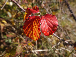
Bramble Colours
I did get a little lost through the reserve as I think I missed a sign.  I eventually did manage to retrace the route and came upon Wiggonholt Church, a delightful chapel sized place of worship.  Due to its remote location, church services don’t take place every week although the door was open to allow inspection inside.  I had the place to myself in this little peaceful spiritual oasis and since I had walked through lots of wet grass to get to it I didn’t even have to worry about muddy boots!

Wiggonholt Church
After a few moments to pay my respects I headed off across towards the RSPB Visitor Centre, which was starting to get very busy with the leisure visitors (all the serious twitchers would have been here for a long time!).  I negotiated the crowds getting out of their cars and heading off to pay their money for what I had just seen for free!  Not that I am advocating an avoidance of payment, just finding it curious that a public footpath heads off right across the reserve.

Inside Wiggonholt Church
My onward path took me through Wiggonholt Common and the pine forest that is at the less visited part of the RSPB reserve.  The light was fantastic through the late autumn forest, with those deciduous trees that are dotted in among the pine trees really showing off the zenith of their colours.  The woods though looked very different today on account of the clear cutting of a section to the left of the path.  Indeed the machinery was still on site and making quite a racket as I approached.  Yet somehow even this destruction couldn’t detract from the beauty of probably the finest part of today’s walk.

Wiggonholt Common
Eventually I came to a road and onward progress needed to be made by tarmac.  In some respects this was a relief as it meant that I would have a break from muddy conditions.  However, this area is not as muddy as most due to the sandy soils of the Common.  I headed along the road for quite some distance, enjoying the autumn colours and the wisps of wood smoke hanging in the air from nearby cottages.  Eventually I came upon the western gateway of Parham Park, with its very attractive looking lodge houses and an exquisitely coloured tree decorating the scene.  Walking across the park is fantastic at this time of year, but sadly it was not on today’s itinerary.

Parham Western Lodge
I re-entered the woods just north of Rackham and initially passed through more sandstone country before dropping down onto the floodplain once again.  This slowed my progress once more as I had to deal with some very sticky conditions.  I was now on the route of the West Sussex Literary Trail, surely a future project?  This is a walk from Chichester to Horsham celebrating some of the places that were haunted by famous classic authors such as Shelley.  I did think that even he would have struggled to wax lyrical about the conditions underfoot today.  I passed by the delightful Rackham Mill, now just a residence rather than a working mill.  The original buildings date from the early 19th Century and present an idyllic spot for someone interested in wildlife and/ or bird watching.

Fiery Autumn Colours
My route continued across a field that had been harvested of its maize, but which had been otherwise left untouched.  I suspect that it got far too wet for machinery to finish the job and it was therefore left to the local pigeons to deal with.  There were certainly plenty of them as I crossed the field, all flying up in unison as I got closer and resettling about fifty metres further forward.  This happened a number of times before they clued into the fact that they ought to encircle me and land behind me.  There were so many it was more like watching a flock of starlings.

Rackham Mill
I was pleased to reach another road as by now I felt like I was walking on platform soles from the large cakes of mud that had developed underneath me.  I soon stomped them off and was able to pick up pace again as I headed through Rackham village.  This linear village has developed along this ridge top road and I soon became aware of the stunning views to my right back across the Arun Valley towards Pulborough where I had started my day.  By now it was approaching lunchtime and the roast dinner brigade were gathering outside The Sportsman pub waiting for their grub.  The twitchers seemed to be out in force too and I passed a large group making use of one of the only spare spots for the view across the valley.  The bulk of the equipment they were carrying was frightening and put my little camera bag into perspective.

Pigeon Field
Eventually the road took me down into Amberley village, one of the most picture postcard downland villages you are ever likely to come across.  In contrast to the activity in Rackham the village seemed very quiet indeed, perhaps explaining the sad demise of the Black Horse pub in the centre of the village.  This is a pub that we had been to a number of times to eat and it was very sad to see it out of business.  Signs up in the village suggested that it might be turned into housing, which wasn’t a popular choice by any means.  I noted that it had a Peter Oldrieve sign outside, surely now living on borrowed time, so I grabbed a picture of it before continuing on.

Black Horse
I had the choice at the village to continue on my planned route via the castle and back along the riverbank or using the road to return to Amberley station.  I chose the river route so that I could get a closer look at the castle.  However, I soon wished that I hadn’t for not only did I see very little of the castle (as it was mostly hidden behind the 60 feet high curtain wall), but I then had to endure the swamp of the River Arun and its floodplain. The castle is now a luxury hotel, with prices starting in excess of £300 per night.  It is a castle of some antiquity though, with a history stretching back to the 1100s and was originally used as a fortification for the Bishops of Chichester.

Amberley Church
Of more interest perhaps than the castle was the church of St Michael, which looked fantastic in the wintry sunshine.  Sadly my boots were in such a state that I didn’t fancy wandering around inside for fear of getting dirty looks from other visitors of which there were a few milling around.  I viewed from outside only but did notice a small gate in the wall of the castle that intrigued me.  I suspect it was a secret entrance to the church for the castle dwellers.

Amberley Castle
The last half hour or so was miserable walking.  The view across to Bury Church was very interesting from the path and this enticed me to continue across the marsh.  It would once have been the footpath to a ferry crossing that existed for 300 years between the two villages, but which ceased in 1965.  I have noticed references to the ferry service still in existence, although stating that the ferry is now closed.  Hardly front page news since it is getting on for 50 years ago!

Bury Church
I cursed and grumbled all the way along the riverbank back to Amberley, wishing I had taken the drier option along the road.  However the views up to the Downs were very enjoyable, as were the sounds of lapwings flying around in the distance.  My rout managed to get me back all the way to the railway station without any further road walking along the busy Houghton road, so I was thankful for that.  All in all a very interesting and varied walk, with plenty of history and natural sights along the way on what was a very modest length of just short of 8 miles.

Tuesday, 23 October 2012

Arun Valley Walks Amberley - Arundel

Arun Rainbow

It’s been a tough time again for walking.  An insanely busy autumn combined with bad weather on the days I have been able to go out meant a five week gap between expeditions, far longer than I normally like.  However, we did manage to find a window of opportunity for a short family walk and decided to do a mirror image of the walk that we did along the Arun Valley during the summer but in reverse and on the other side of the valley.

North Stoke Lane

We caught the train from Arundel to Amberley and the sunny day that we had started with soon turned overcast and rainy looking as showers came in from the west.  As we got off the train it was clear that one of the showers had only just tracked through as the ground was very wet everywhere.  

North Stoke Cottages
The sky was still grey as we wandered along the main road trying to avoid the traffic.  The road past the station is no a pleasant one to walk along but almost unavoidable if using the station as a staging point.  We opted not to use the riverbank walk this time, on account of the mud everywhere, but headed along the lane towards North Stoke village instead.

Arun Valley From North Stoke

The lane proved to be an easy if not very interesting route.  As we wandered along a couple of cars passed us and from the looks on the drivers’ faces we knew they would be back shortly after as they looked lost and didn’t realise they were heading along a dead end road.  Sure enough they did come back a few minutes later, when it wasn’t easy to get out of the way!  Despite the easy conditions of the road we were relieved to lose the tarmac and head out into the countryside just shy of North Stoke village.

Frisky Sheep
We headed up a modest slope, just about the only climb of the day, and at the top we had gained enough height to get a great view of the valley before us.  Annoyingly the black clouds were really building now and although we were in a window of sunshine, the signs were ominous.  Sure enough, about 10 minutes later as we headed along the valley a little longer the heavens opened and we faced quite a downpour.  We tried our best to hide under the trees, but we did end up getting pretty wet for our troubles.

Burpham Church
The woods were looking quite autumnal, with plenty of fungi coming through and the leaves mostly burned off.  The ox-bow lakes that the trees were growing in had a fair amount of water in them, signalling the amount of water that has fallen from the sky this year!  Usually I have only seen them empty when coming along here.

The George and Dragon
Our route continued along the flood plain which was as squelchy as you might imagine.  The rain finally relented and we did manage to see the inevitable rainbow, this time one that went completely across the sky and which had a hint of a double about it, although the second was very faint.  We also passed a field of very frisky sheep at this point, who all came running towards us (perhaps thinking they might be fed by us?).  Luckily they decided that we weren’t as interesting as we looked and moved off in another direction as we got closer.

Burpham View
At Burpham we headed up off the floodplain to the higher ground on which the village stood.  Despite its very modest size, the church looked well used and the pub also looked like it was in decent health.  We stopped to have a look around the churchyard for a short time and I couldn’t help noticing the clock, which appeared to be a recent installation.  I wasn’t sure if it had always had a clock or whether it was completely new?  Sadly the layers of mud on our feet were not conducive to an inside visit – maybe we’ll have to come again another time?

Plane Trees

We left the village via the cricket field and passed by a well-appointed looking cricket pavilion.  The girls were most disappointed that the playground equipment was so wet that they couldn't realistically play on it.  I was ordered to take a picture of it so they could remember for next time.  Our path led down a set of steps called Jacobs Ladder - so many flights of steps are called this.  Given the muddiness of this set I couldn't imagine them leading to heaven, like the biblical reference suggests!  Actually we were lucky to get to the bottom staying on our feet.  At the bottom we made our way along the riverbank for a short way through more mud.  Alongside us a wall of reeds waved in the breeze while the views across the valley were superb.

Last Leaves
By now the girls were getting a little tired so we took the opportunity to cut off a corner of the river and headed across the fields and through avenues of plane trees to the small hamlet of Warningcamp.  Through the woods the colours of autumn were well under way and everything smelled earthy and damp.  As I took pleasure in my surroundings the children took a lot of pleasure in telling each other stories, with our surroundings clearly firing their little imaginations.

Arun Valley Train

At Warningcamp we crossed the railway on the level, which was a new experience for the girls.  They were understandably nervous about it and we crossed very quickly.  On the other side there was an old lady who initially passed the time of day with us, but soon joined us for a lengthier chat.  I contented myself with enjoying the views across to Arundel Castle and listening to the rather surreal shouts coming from Arundel FC that was out of sight.  I always think that non-league football games have a strange atmosphere about them when you can't see the action.

Arundel Castle

I soon became aware of a very large dark cloud up ahead and quickened my pace as we got closer to Arundel.  I really wanted to get some good sunlit shots of the castle and I was partly successful.  However as I rounded the corner to get the full on view of the castle so beloved of all postcards I lost the sun.  Talk about sod's law!


Stoke Hill
We parted company with our old lady at the edge of Arundel and learned that she did the ver same walk every day!  It was a lovely walk that is for sure and a pleasurable way of spending the afternoon.  I think next time I would like to come when there is a lot less mud!

Arundel

Saturday, 7 July 2012

Arun Valley Walks - Arundel to Amberley

Arundel View

After the success of our family expedition a couple of weeks ago the weather was nice enough for us to have another go & so we had to find another route that was of similar length that had enough interesting things to see on the way that the girls would enjoy the experience.  Not really an official walk, but one which I had fancied for some time was to walk across Arundel Park and the Arun Valley between Amberley and Arundel, in a sense continuing the exploration of the countryside that would have been followed by canal craft using the ‘Lost Route to London’ followed in part by the Wey-South Path that I completed in 2009.  However, in view of the windy weather, the small children we had with us and having the sun at our backs we followed the route northwards from Arundel.

Arundel High Street

The journey on the train from Amberley is an hourly frequency and takes only five minutes, but left the wallet a bit light, being a very steep £7.40 for the four of us!  Arundel station isn’t the most convenient, dumping passengers on the busy A27 about half a mile to the south east of the town and leaving a rather unpleasant walk for would be visitors to the town.  Luckily, when we reached the bridge over the River Arun things improved immeasurably.  The bridge was the first opportunity for a sit down and the surroundings were pleasant enough for the girls to want their picnic already.  This worked out nicely as it meant that we had less to carry for the rest of the trip!


Arundel Post Office

Looking at the size of the River Arun, it is hard to believe that this was once a thriving port.  The odd pleasure boat comes through here now, but the former wharves have long since been replaced by housing.  Littlehampton took over port duties from Arundel some miles further downstream, but even that has long since ceased to be a port in the meaningful sense. 

Castle South gate


Arundel is probably one of the most picturesque towns in all of Sussex (and there is quite a lot of competition in that regard).  On this sunny Saturday it really looked at its best and despite the odd closed shop the town centre looked to be in fairly rude health.  We marched up the hill past all the antique shops and galleries designed to cater for the many tourists that descend on the town.  At the top we passed the enormous gateway to Arundel Castle, the gothic seat of the Dukedom of Norfolk.  Strangely, I have not visited the castle since before I can remember, but have a feeling that this will change very soon!  The castle itself is a bit of a sham, as much of what can be seen is the Victorian vision of how a castle should look.  There is an original castle somewhere inside but it isn’t easy to see from outside the walls.

Arundel Castle

Further along the road and we passed by Arundel Cathedral, another gothic creation that vies with the castle for prominence on the Arundel skyline.  It probably succeeds from the western side since the Castle occupies the eastern slopes of the town.  The Cathedral wasn’t dedicated as such until 1965, as the main Catholic Church of the newly formed diocese of Arundel and Brighton.  The girls were in a hurry to get out on to the open Downs so they could run about so only a cursory look at the architecture was afforded as we passed by.

Arundel Cathedral

We crossed the road and headed up past the cricket ground.  This is one of the most picturesque grounds in all of Britain, hosting at least one County Championship game for Sussex each year and is a thoroughly enjoyable place to watch this most English of games.  The arena is not actually visible from the track sadly, but ahead we could see Hiorne Tower, which acted as a good focal point for the way ahead.  The tower was built as a folly by Francis Hiorne for the 11th Duke of Norfolk in the 18th Century for apparently no better reason than proof that he could.

Hiorne Tower

The onward path wasn’t quite so easy to spot as we headed down into Swanbourne Valley below.  This heads down slowly to a point where two dry valleys meet to become the one that is now occupied by a small lake so beloved of water birds from miles around.  Normally our walk in this area extends only as far as a loop around the lake.  Today though we would be heading onward, up the initially steep hill on the other side to the very top of Arundel Park.  We plodded our way slowly up the hill, admiring the wild flowers as we did so.  This year seems to have been a bumper one for wild flowers – they are in such profusion everywhere and this part of the Downs was no exception!


Arundel Park
We were rewarded at the top of the hill with one of the best views from anywhere on the Downs, looking out towards the upper reaches of the River Arun.  Far below the river meanders around the base of the hill we were stood on, cutting a cliff as it does so.  The puffy white clouds together with the wind made for some interesting shadow patterns on the landscape as they raced along.  In fact the skyscape was almost as interesting as the landscape, with high level cirrus type clouds in evidence high above the fair weather clouds.  Trails from aeroplanes heading to the London airports also added to the mix, creating some very interesting patterns indeed.
Arundel Park View

For us though the high level walking was very short lived as our path headed down the other (steeper) side of the hill.  The wildflowers that had been lost through the sheep fields that we had travelled through now returned in profusion, mostly a palette of purples and yellows, with the odd common spotted orchid thrown in.  It was quite a steep track though and we had to keep our wits about us so as not to slip over.  At the bottom where we entered some woodland the path was especially slick after all the rain we had had.

Common Spotted Orchid

We passed through the large flint wall that surrounds Arundel Park and turned right to follow the path back towards Arundel alongside the River Arun.  We wanted to cross the river at South Stoke via the only bridge in these parts.  The path through the woods was no joke though – some of the forestry vehicles had obviously been this way before us and there were a lot of very large muddy puddles disrupting our progress.  For the kids this only added to the adventure of the trip, especially as it was touch and go in some instances whether they could hang on to their shoes!

Shadow Over the Barley

Eventually we picked our way through the woods and came out into a section alongside some large barley fields.  The combination of sun breaking through the clouds, picking out certain parts of the fields and the wind waving the feathery crops around was quite a mesmerising spectacle that we all enjoyed.  Eventually we reached the  small village of South Stoke, where we stopped in the churchyard for a bit of a breather and an afternoon snack to help small people’s energy levels.  Fortunately St Leonard's Church was open and so we took the opportunity to look inside.  It was a very peaceful church, not very large but well kept and with a modest stained glass window at one end.  The church itself was built of knapped flint, like most proper downland churches, but also had an unusually thin tower.  In the churchyard was a small flock of sheep being used to try and tackle some of the grass that had grown up around the graves.

Fearsome Mud

After some refreshment and a few minutes to rest we pushed on, heading around the perimeter of the church and making our way down to the River Arun.  We crossed via the substantial bridge that looked as if it were provided for a possible road route that never quite happened.  A look at the map will show that the roads stop no more than about half a mile apart on either side of the river.  I guess having a through route would encourage far too much traffic, so perhaps it is a godsend that it doesn’t exist, for the tranquillity of the valley.

St Leonard's Church

We turned immediately left and followed the riverbank for a short distance before heading through another stretch of woodland that appeared to follow a former meander loop.  Again the mud through here was fearsome in places and we had to lift the children over the worst of it.  Yet, the flowers through here were doing really well, with guelder rose, elderberries, cow parsley and briar roses all doing really well and adding a lot of colour to the woods.  The second bridge of our walk was a distinctive little suspension bridge, which seemed to take us across the bog that had now formed from the old meander loop.

Arun Bridge

The field the other side was full of bullocks – almost all of them stopped what they were doing as we headed through and stared at us.  It made us all feel rather self conscious!  We headed quickly but steadily across the field, breathing something of a sigh of relief the other side (although we weren’t seriously in any danger).  At the far end of the field we entered the village of North Stoke, a place that seemed to be stuck in a time warp, well out of range of normal passing traffic or visitors, stuck down here at the end of a lengthy cul-de-sac road.  I guess this would be an ideal place to live for lovers of peace and quiet!

North Stoke Suspension Bridge

We headed along the road initially for the last leg of the journey, but soon opted to take a slightly longer route along a footpath heading back to the river after we had some uncomfortable encounters with cars.  The footpath turned out to be little better as we had to use various pieces of wood to try and help us cross the path-wide puddles that had formed.  By the time we had reached the riverbank once again we had stretched every leg muscle possible trying to avoid the worst of the mud, getting stung or prickled!  At the riverbank we found another obstacle in the shape of another herd of bullocks completely blocking the path the other side of our stile.  They formed quite a formidable barrier to our onward progress but luckily a few handclaps soon moved them on and they didn’t cause any bother.  The rest of the walk along the riverbank to Houghton Bridge was uneventful and surely nicer than walking along the road.

Being Watched

We did face one last unpleasant stretch though across Houghton Bridge, a rather narrow structure that can only just accommodate two lanes of traffic.  As pedestrians the crossing is a little scary, so we hurried across when there was a momentary absence of traffic.  It was a bit of a sting in the tail after such a pleasant and peaceful walk.  We were really proud of the children who completed the five miles with no great problems and had a thoroughly good time exploring on the way.  I have a feeling we may well try other routes in this area, helped by the presence of the train line.  There are numerous possibilities between Billingshurst and Littlehampton to keep us amused!

Houghton Bridge